Arkivo:Un-kenya.png
Arkivo originala (2 367 × 3 092 pixel-i, grandeso dil arkivo: 2,04 MB, MIME type: image/png)
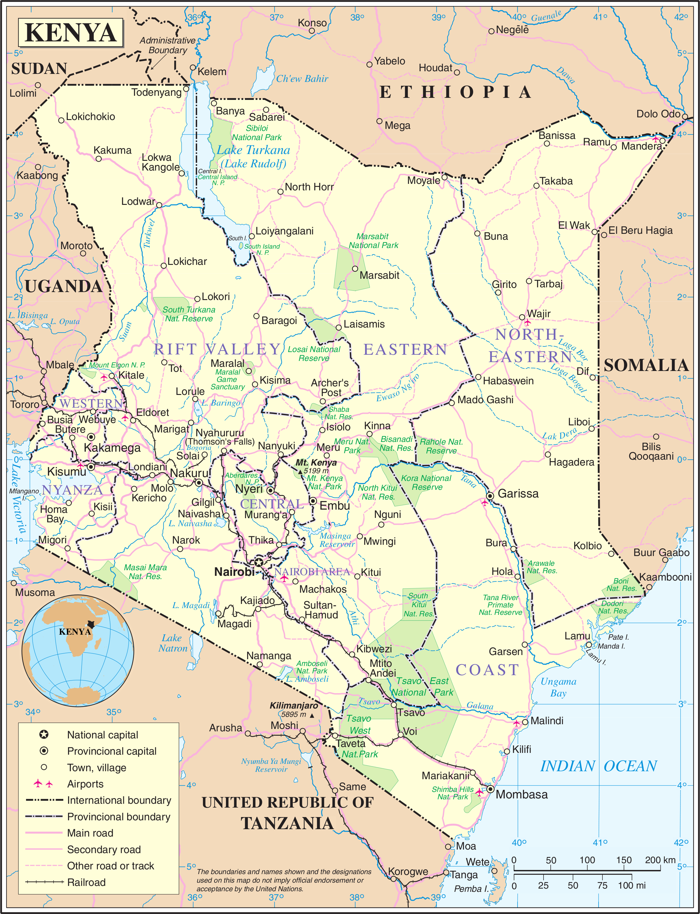
| This image is a map derived from a United Nations map.
Unless stated otherwise, UN maps are to be considered in the public domain. This applies worldwide. UN maps are, in principle, open source material and you can use them in your work or for making your own map. UN requests however that you delete the UN name, logo and reference number upon any modification to the map. Content of your map will be your responsibility. You can state in your publication, if you wish, something like: based on UN map … (map name, map number, revision number and date). See: Geospatial Information Section. And: Geospatial, location data for a better world. |
 |
http://www.akwaaba.nl/foto's%20en%20plaatjes/kaart_kenia.jpg
Historio dil arkivo
Kliktez sur la dato/horo por vidar arkivo quale ol aparis ye ta tempo.
| Dato/Horo | Miniaturo | Dimensioni | Uzero | Komento | |
|---|---|---|---|---|---|
| aktuala | 00:15, 22 okt. 2007 | | 2 367 × 3 092 (2,04 MB) | Jeroen | {{UN map}} Category:Maps of Kenya |
Ligilo al imajo
Ca pagini ligas al imajo:
Uzado en altra Wiki
La sequanta Wiki anke uzas ica arkivo:
- Uzado en ar.wikipedia.org
- Uzado en azb.wikipedia.org
- Uzado en az.wikipedia.org
- Uzado en bn.wikipedia.org
- Uzado en en.wikipedia.org
- Uzado en es.wikipedia.org
- Uzado en fa.wikipedia.org
- Uzado en fi.wikipedia.org
- Uzado en hu.wikipedia.org
- Uzado en hy.wikipedia.org
- Uzado en incubator.wikimedia.org
- Uzado en my.wikipedia.org
- Uzado en nds-nl.wikipedia.org
- Uzado en nds.wikipedia.org
- Uzado en nl.wikipedia.org
- Uzado en pl.wikipedia.org
- Uzado en pl.wiktionary.org
- Uzado en si.wikipedia.org
- Uzado en sl.wikipedia.org
- Uzado en sr.wikipedia.org
- Uzado en te.wikipedia.org
- Uzado en tr.wikipedia.org
- Uzado en uk.wikipedia.org
- Uzado en www.wikidata.org