Arkivo:Transoxiana 8th century.svg

Grandezo di la previdado PNG de ica arkivo SVG: 800 x 388 pixels. Altra qualeso, en pixel-i: 320 x 155 pixels | 640 x 310 pixels | 1 024 x 496 pixels | 1 280 x 620 pixels | 2 560 x 1 241 pixels | 1 300 x 630 pixels.
Arkivo originala (arkivo SVG, nominale 1 300 x 630 "pixels", kun 1,86 MB)
Titulo
| Deskripto |
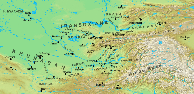
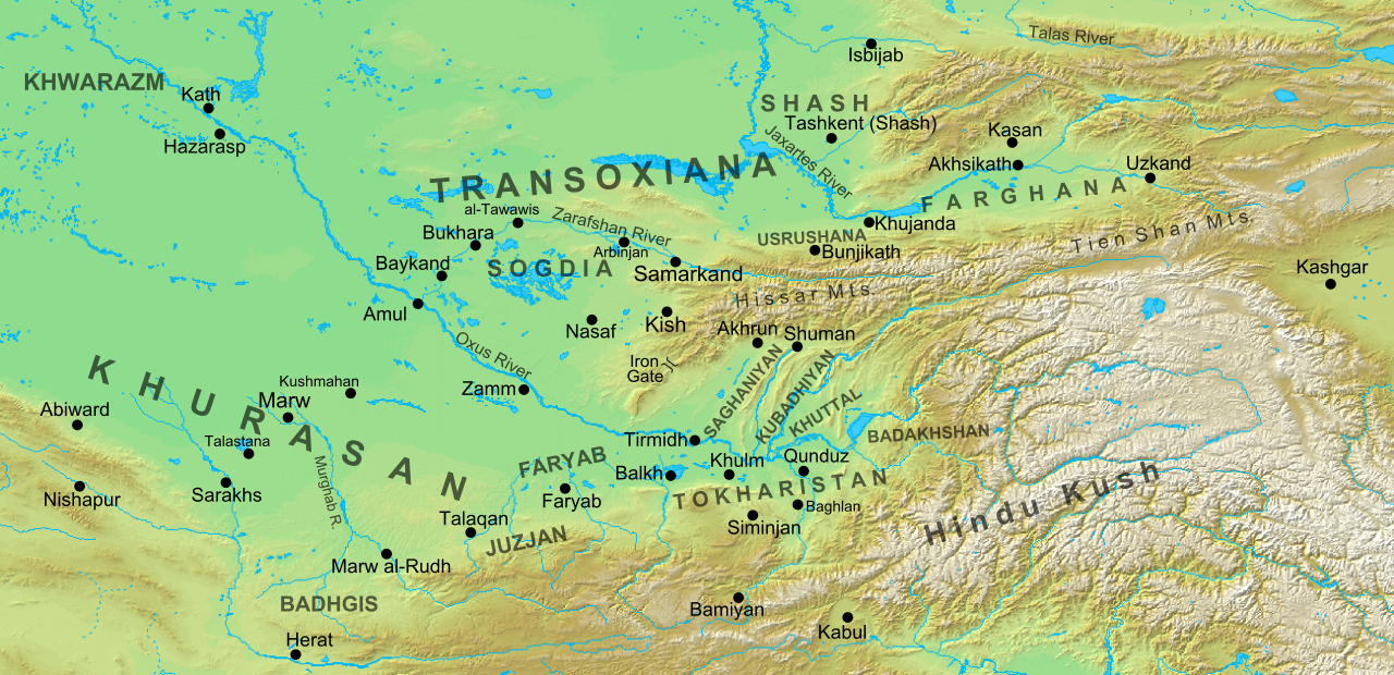
English: Map of the region and principal localities of Transoxiana in the 8th century —.
|
| Dato | |
| Fonto | Propra verko |
| Autoro | Cplakidas |
| Altra versioni |
[]
|


Licencizo
Me, la posedanto dil autoroyuro pri ica imajo/arkivo, permisos lua uzado camaniere:
Ica arkivo liberigesas sub permiso Creative Commons Attribution-Share Alike 3.0 Unported.
- Vu povas:
- partigar – kopiar, distributar e transsendar la verko
- Mixar – adaptar l'arkivo
- Segun la sequanta kondicioni:
- Atribuo – Vu mustas referar l'artiklo o verko segun la formo definita dal autoro o dal proprietero dil autoroyuro, ed informar se modifikuri facesis. Vu mustas facar to per justa formo, ma ne insinuar ke l'autoro konfidis ol a vu, od aprobis vua uzo dil artiklo.
- partigar identa ('share alike') – Se vu modifikos, transformos od augmentos ica verko, vu mustos distributar la rezulto segun la sama, o simila licenco, quale l'originalo.
Historio dil arkivo
Kliktez sur la dato/horo por vidar arkivo quale ol aparis ye ta tempo.
| Dato/Horo | Miniaturo | Dimensioni | Uzero | Komento | |
|---|---|---|---|---|---|
| aktuala | 15:30, 2 okt. 2016 | | 1 300 × 630 (1,86 MB) | Cplakidas | added Qunduz |
| 10:32, 15 okt. 2012 |  | 1 300 × 630 (1,86 MB) | Cplakidas | larger map to include most of Khurasan, additions of cities & provinces | |
| 13:29, 24 jan. 2012 |  | 800 × 500 (1 MB) | Cplakidas | major revision with more additions & corrections | |
| 17:28, 8 dec. 2011 |  | 800 × 500 (955 KB) | Cplakidas | added more details, some corrections | |
| 20:34, 25 jul. 2011 |  | 800 × 500 (895 KB) | Cplakidas |
Ligilo al imajo
Ca pagini ligas al imajo:
Uzado en altra Wiki
La sequanta Wiki anke uzas ica arkivo:
- Uzado en arz.wikipedia.org
- Uzado en azb.wikipedia.org
- Uzado en az.wikipedia.org
- Türkdilli dövlətlər
- Usruşana
- Börküyarıq
- Talas döyüşü
- Bahilə qalası uğrunda döyüş
- Susuzluq günü
- Ağsu döyüşü (717)
- Bəykənd döyüşü
- Vikipediya:Həftənin yaxşı məqaləsi/noyabr 2020
- Vikipediya:Həftənin yaxşı məqaləsi/dekabr 2020
- Vikipediya:Həftənin yaxşı məqaləsi/48. Həftə 2020
- Vikipediya:Həftənin yaxşı məqaləsi/49. Həftə 2020
- Böyük Xorasan
- Uzado en bg.wikipedia.org
- Uzado en bn.wikipedia.org
- Uzado en bs.wikipedia.org
- Uzado en ca.wikipedia.org
- Uzado en cs.wikipedia.org
- Uzado en de.wikipedia.org
- Uzado en de.wikiversity.org
- Uzado en el.wikipedia.org
- Uzado en en.wikipedia.org
Videz altra uzadi por ica artiklo.