Arkivo:Nya Sverige.svg

Grandezo di la previdado PNG de ica arkivo SVG: 342 x 599 pixels. Altra qualeso, en pixel-i: 137 x 240 pixels | 274 x 480 pixels | 439 x 768 pixels | 585 x 1 024 pixels | 1 170 x 2 048 pixels | 720 x 1 260 pixels.
Arkivo originala (arkivo SVG, nominale 720 x 1 260 "pixels", kun 461 KB)
Titulo
| Deskripto |
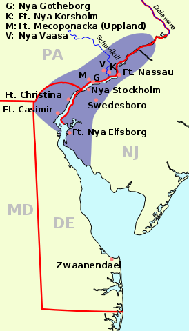
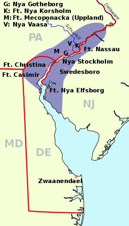
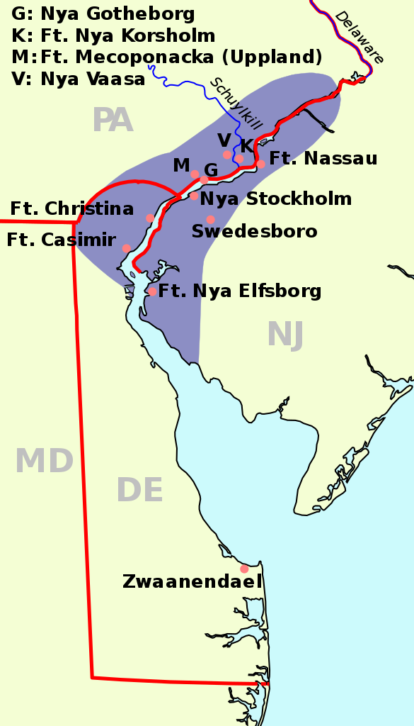
English: The map of New Sweden, 1638 Deutsch: Karte von Neu-Schweden, 1638. Русский: Карта Новой Швеции, 1638 год |
||
| Dato | (UTC) | ||
| Fonto | |||
| Autoro |
|
||
| SVG genesis | Ĉi tiu map estas kreita per tekstoredaktilo. La valideckontrolo konstatis sintaksan ĝustecon.
|
| See also: Nieuw Nederland and Nya Sverige |
Ica arkivo liberigesas sub permiso Creative Commons Attribution-Share Alike 3.0 Unported.
- Vu povas:
- partigar – kopiar, distributar e transsendar la verko
- Mixar – adaptar l'arkivo
- Segun la sequanta kondicioni:
- Atribuo – Vu mustas referar l'artiklo o verko segun la formo definita dal autoro o dal proprietero dil autoroyuro, ed informar se modifikuri facesis. Vu mustas facar to per justa formo, ma ne insinuar ke l'autoro konfidis ol a vu, od aprobis vua uzo dil artiklo.
- partigar identa ('share alike') – Se vu modifikos, transformos od augmentos ica verko, vu mustos distributar la rezulto segun la sama, o simila licenco, quale l'originalo.
Originala protokolo dum sendado dil arkivo
This image is a derivative work of the following images:
- File:Nya Sverige.png licensed with Cc-by-sa-3.0-migrated, GFDL, PD-self
- 2005-10-12T00:50:54Z Arnapha 306x528 (6492 Bytes) Map of New-Sweden ca. 1650 Created on base of the maps of Delaware and New Jersey from the Perry Castañeda Library (at http://www.lib.utexas.edu/maps/united_states.html). Transferred from German Wikipedia (http://de.wikipe
- File:USA New Jersey location map.svg licensed with Cc-by-3.0, GFDL
- 2009-06-17T19:59:27Z Alexrk2 839x1560 (259806 Bytes) enh
- 2009-06-13T18:01:16Z Alexrk 839x1560 (198653 Bytes) fixed SVG bug
- 2009-06-13T17:46:17Z Alexrk 839x1560 (246056 Bytes) == Beschreibung == {{Information |Description= {{de|Positionskarte von [[:de:New Jersey|New Jersey]], [[:de:USA|USA]]}} Quadratische Plattkarte, N-S-Streckung 130.0 %. Geographische Begrenzung der Karte: * N: 41.6° N * S: 38
- File:USA New York location map.svg licensed with Cc-by-3.0, GFDL
- 2009-06-10T11:28:20Z NordNordWest 1572x1277 (597043 Bytes) {{Information |Description= {{de|Positionskarte vom Bundesstaat [[:de:New York (Bundesstaat)|New York]], [[:de:USA|USA]]}} Quadratische Plattkarte, N-S-Streckung 135 %. Geographische Begrenzung der Karte: * N: 45.3° N * S: 4
- File:USA Delaware location map.svg licensed with Cc-by-3.0, GFDL
- 2009-06-22T10:54:18Z Alexrk2 470x800 (106507 Bytes) renderer bug
- 2009-06-22T10:39:54Z Alexrk2 470x800 (66078 Bytes) == Beschreibung == {{Information |Description= {{de|Positionskarte von [[:de:Delaware|Delaware]], [[:de:USA|USA]]}} Quadratische Plattkarte, N-S-Streckung 130.0 %. Geographische Begrenzung der Karte: * N: 40.0° N * S: 38.3°
Uploaded with derivativeFX
Historio dil arkivo
Kliktez sur la dato/horo por vidar arkivo quale ol aparis ye ta tempo.
| Dato/Horo | Miniaturo | Dimensioni | Uzero | Komento | |
|---|---|---|---|---|---|
| aktuala | 08:23, 1 jan. 2011 | | 720 × 1 260 (461 KB) | Arnapha | adapted size |
| 06:05, 1 jan. 2011 |  | 730 × 1 270 (461 KB) | Arnapha | moved origin | |
| 06:01, 1 jan. 2011 |  | 730 × 1 270 (461 KB) | Arnapha | use total viewBox | |
| 05:12, 1 jan. 2011 |  | 1 020 × 1 760 (461 KB) | Arnapha | text position | |
| 04:18, 1 jan. 2011 |  | 1 020 × 1 760 (461 KB) | Arnapha | removed unused items | |
| 02:26, 1 jan. 2011 |  | 1 020 × 1 760 (644 KB) | Arnapha | {{Information |Description={{en|The map of New Sweden, 1638. Created on base of the maps of Delaware and New Jersey from the Perry Castañeda Library (at [http://www.lib.utexas.edu/maps/united_states.html www.lib.utexas.edu]).}} {{de|Karte von Neu-Schwede |
Ligilo al imajo
Ca pagini ligas al imajo:
Uzado en altra Wiki
La sequanta Wiki anke uzas ica arkivo:
- Uzado en af.wikipedia.org
- Uzado en azb.wikipedia.org
- Uzado en be.wikipedia.org
- Uzado en bg.wikipedia.org
- Uzado en bs.wikipedia.org
- Uzado en ca.wikipedia.org
- Uzado en cs.wikipedia.org
- Uzado en da.wikipedia.org
- Uzado en de.wikipedia.org
- Uzado en en.wikipedia.org
- Uzado en es.wikipedia.org
- Uzado en fi.wikipedia.org
- Uzado en fr.wikipedia.org
- Uzado en fy.wikipedia.org
- Uzado en he.wikipedia.org
- Uzado en hr.wikipedia.org
- Uzado en hu.wikipedia.org
- Uzado en it.wikipedia.org
- Uzado en li.wikipedia.org
- Uzado en nds.wikipedia.org
- Uzado en nl.wikipedia.org
- Uzado en no.wikipedia.org
- Uzado en pl.wikipedia.org
- Uzado en pt.wikipedia.org
- Uzado en ru.wikipedia.org
- Uzado en sh.wikipedia.org
- Uzado en sr.wikipedia.org
- Uzado en sv.wikipedia.org
Videz altra uzadi por ica artiklo.