Arkivo:Snow-cholera-map.jpg

Arkivo originala (889 × 869 pixel-i, grandeso dil arkivo: 248 KB, MIME type: image/jpeg)
Titulo
| Priskribo |
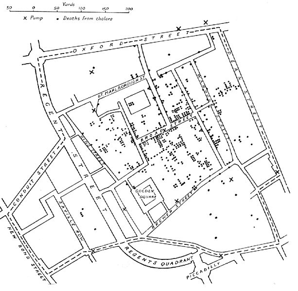
English: A variant of the original map drawn by Dr. John Snow (1813-1858), a British physician who is one of the founders of medical epidemiology, showing cases of cholera in the London epidemics of 1854, clustered around the locations of water pumps.
Español: Mapa original dibujado por el Dr. John Snow (1813-1858), médico inglés precursor de la epidemiología, que muestra los casos de cólera en la epidemia ocurrida en Londres en 1854. Los puntos muestran la localización de las personas afectadas por beber agua de los pozos (cruces)
Português: Mapa original elaborado pelo Dr. John Snow (1813-1858), médico britânico, um dos precursores da epidemiologia. O mapa mostra casos de cólera numa epidemia ocorrida em Londres em 1854. Os pontos indicam a localização de pessoas afetadas pela cólera por consumir água de poços, indicados pelas cruzes.
Nederlands: De originele kaart gemaakt door Dr. John Snow (1813-1858), een Engelse arts en een van de grondleggers van de medische epidemiologie, laat zien waar gevallen van cholera plaatsvonden tijdens de Londense epidemie van 1854, in relatie tot de waterpompen (kruisjes).
Deutsch: Variante einer im Original von Dr. John Snow (1813–1858) gezeichneten Karte. Der britische Arzt war ein Pionier der epidemiologischen Erforschung der Cholera. Die Karte zeigt Cholerafälle bei der Epidemie in London 1854, die sich bei einer Wasserpumpe (an der Broad Street) häufen. |
|||||||||
| Fonto |
Nekonata Transferred from en.wikipedia to Commons. |
|||||||||
| Kreinto |
after John Snow |
|||||||||
| Geotemporal data | ||||||||||
| Bounding box |
|
|||||||||
| Georeferencing | ||||||||||
| Altra versioni | File:Snow-cholera-map-1.jpg, the original | |||||||||
Licencizo
|
Tiu ĉi verko estas publika havaĵo en tiuj landoj, kies kopirajtado validas por longo de vivo plus 70 jaroj aŭ malpli.
| |
| Questo file è stato riconosciuto come libero da restrizioni di cui si abbia contezza ai sensi della normativa sul diritto d'autore, inclusi tutti i diritti annessi e connessi. | |
Historio dil arkivo
Kliktez sur la dato/horo por vidar arkivo quale ol aparis ye ta tempo.
| Dato/Horo | Miniaturo | Dimensioni | Uzero | Komento | |
|---|---|---|---|---|---|
| aktuala | 11:10, 6 nov. 2005 | | 889 × 869 (248 KB) | Corso | *{{english}}The original map drawn by Dr. John Snow (1813-1858), a British physician who is one of the founders of medical epidemiology, showing cases of cholera in the London epidemics of 1854, clustered around the locations of water pumps. *{{spanish}} |
Ligilo al imajo
Ca pagini ligas al imajo:
Uzado en altra Wiki
La sequanta Wiki anke uzas ica arkivo:
- Uzado en ast.wikipedia.org
- Uzado en bg.wikipedia.org
- Uzado en bn.wikipedia.org
- Uzado en bs.wikipedia.org
- Uzado en ca.wikipedia.org
- Uzado en cs.wikipedia.org
- Uzado en de.wikipedia.org
- Uzado en en.wikipedia.org
- Uzado en en.wikiversity.org
- Uzado en eo.wikipedia.org
- Uzado en es.wikipedia.org
- Uzado en et.wikipedia.org
- Uzado en eu.wikipedia.org
- Uzado en ext.wikipedia.org
- Uzado en fi.wikipedia.org
- Uzado en fr.wikipedia.org
- Uzado en hi.wikipedia.org
- Uzado en hr.wikipedia.org
- Uzado en hu.wikipedia.org
- Uzado en it.wikipedia.org
- Uzado en ja.wikipedia.org
Videz altra uzadi por ica artiklo.