Arkivo:Ogasawara islands.png
Grandeso de ica previdado: 760 x 600 pixels. Altra qualeso, en pixel-i: 304 x 240 pixels | 608 x 480 pixels | 1 011 x 798 pixels.
Arkivo originala (1 011 × 798 pixel-i, grandeso dil arkivo: 296 KB, MIME type: image/png)
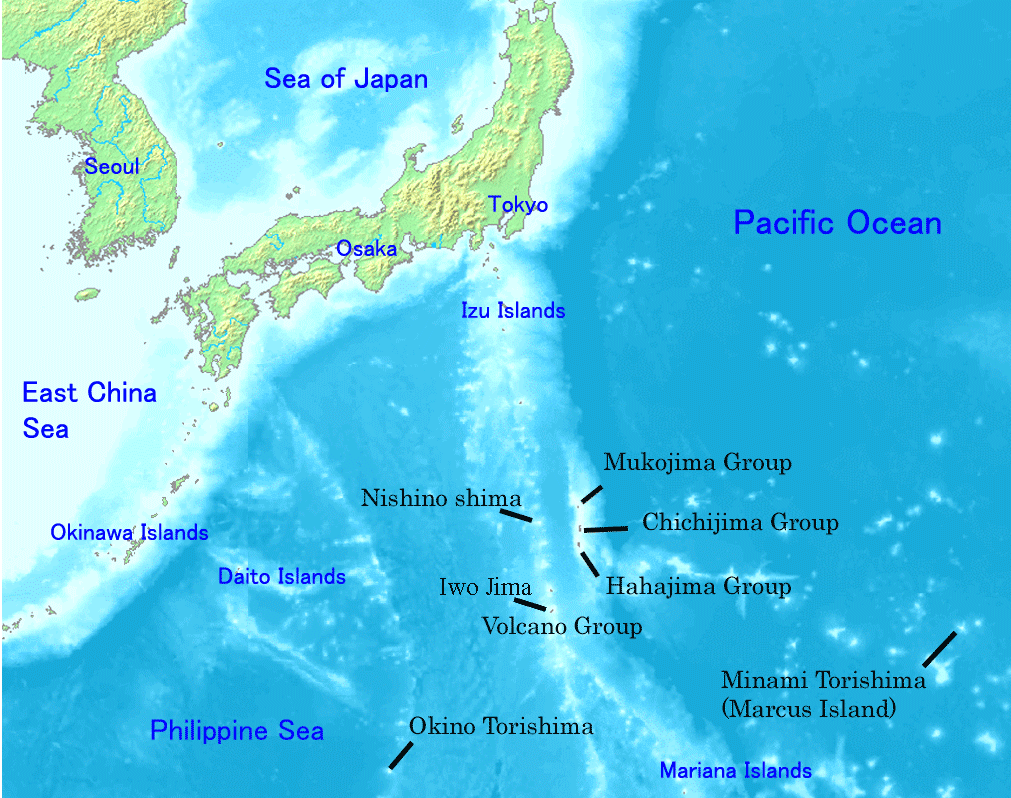
Map of Ogasawara Islands. Created by Map of ogasawara islands.png
This image is in the public domain because it came from the site https://www.demis.nl/products/web-map-server/examples/ and was released by the copyright holder. Permission is granted to copy, distribute and/or modify this map since it is based on free of copyright images from: www.demis.nl. See also approval email on de.wp and its clarification.
|
| This work has been released into the public domain by its copyright holder, www.demis.nl. This applies worldwide. In alcuni paesi questo atto potrebbe non essere riconosciuto valido dalla locale normativa; in tal caso: www.demis.nl donas al iu ajn la rajton uzi ĉi tiun verkon por iu ajn uzo, sen kondiĉoj, krom se tiuj kondiĉoj deviĝas per leĝo.
|
Historio dil arkivo
Kliktez sur la dato/horo por vidar arkivo quale ol aparis ye ta tempo.
| Dato/Horo | Miniaturo | Dimensioni | Uzero | Komento | |
|---|---|---|---|---|---|
| aktuala | 22:01, 31 dec. 2007 | | 1 011 × 798 (296 KB) | Sagredo | Created by [http://commons.wikimedia.org/wiki/Image:Map_of_ogasawara_islands.png Map of ogasawara islands.png] {{Information |Description=Map of Ogasawara Islands. |Source= |Date= |Author= |Permission={{demis-pd}} }} |
| 05:29, 30 apr. 2006 |  | 1 011 × 798 (260 KB) | Tdk~commonswiki | Map of Ogasawara Islands. Created by [Image:Map of ogasawara islands.png] {{demis-pd}} |
Ligilo al imajo
Ca pagini ligas al imajo:
Uzado en altra Wiki
La sequanta Wiki anke uzas ica arkivo:
- Uzado en ar.wikipedia.org
- Uzado en ast.wikipedia.org
- Uzado en az.wikipedia.org
- Uzado en ban.wikipedia.org
- Uzado en ca.wikipedia.org
- Uzado en cs.wikipedia.org
- Uzado en cy.wikipedia.org
- Uzado en en.wikipedia.org
- Geography of Japan
- Tokyo
- List of islands of Japan
- Bonin Islands
- Ogasawara, Tokyo
- Japanese archipelago
- Nanpō Islands
- Portal:Japan
- Bonin white-eye
- Wikipedia:Graphics Lab/Images to improve/Archive/Jan 2008
- Ogasawara Subprefecture
- Wandering Island
- List of governors of the Nanpō Islands
- Geography of the Bonin Islands
- Uzado en eo.wikipedia.org
- Uzado en es.wikipedia.org
- Uzado en eu.wikipedia.org
- Uzado en fa.wikipedia.org
- Uzado en fi.wikipedia.org
- Uzado en fr.wikipedia.org
- Uzado en gl.wikipedia.org
- Uzado en he.wikipedia.org
- Uzado en hr.wikipedia.org
- Uzado en hy.wikipedia.org
- Uzado en id.wikipedia.org
- Uzado en ilo.wikipedia.org
Videz altra uzadi por ica artiklo.