Arkivo:Map of Izu Islands.png

Grandeso de ica previdado: 535 x 600 pixels. Altra qualeso, en pixel-i: 214 x 240 pixels | 428 x 480 pixels | 685 x 768 pixels | 1 257 x 1 409 pixels.
Arkivo originala (1 257 × 1 409 pixel-i, grandeso dil arkivo: 691 KB, MIME type: image/png)
Titulo
| Deskripto |
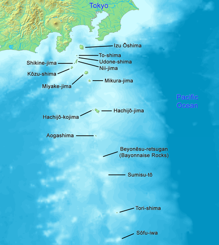
English: High quality map of the Izu Islands. This is the English (Romaji) version with Japanese names. Created with DEMIS World Map Server.
日本語: 日本語:高品質の地図、伊豆諸島。 |
| Dato | |
| Fonto | Propra verko |
| Autoro | Artanisen |
| Altra versioni |
|

Licencizo
This image is in the public domain because it came from the site https://www.demis.nl/products/web-map-server/examples/ and was released by the copyright holder. Permission is granted to copy, distribute and/or modify this map since it is based on free of copyright images from: www.demis.nl. See also approval email on de.wp and its clarification.
|
| This work has been released into the public domain by its copyright holder, www.demis.nl. This applies worldwide. In alcuni paesi questo atto potrebbe non essere riconosciuto valido dalla locale normativa; in tal caso: www.demis.nl donas al iu ajn la rajton uzi ĉi tiun verkon por iu ajn uzo, sen kondiĉoj, krom se tiuj kondiĉoj deviĝas per leĝo.
|

|
Tiu ĉi bildo map respektive ĉiuj bildoj en tiu ĉi artikolo aŭ kategorio prefere estu rekreata(j) kiel vektora grafikaĵo en la formato SVG. Vektoraj formatoj por grafikaĵoj havas multajn avantaĝojn, detaloj troveblas anglalingve en la komuneja artikolo Commons:Media for cleanup. Se vi havas aŭ kreas SVG-version de tiu ĉi bildo, bonvolu alŝuti ĝin al la vikipedia komunejo. Post tiu ago, ĉi tiu ŝablono en la bildpaĝo estas anstataŭigenda per la ŝablono {{vector version available|nova dosiera nomo.svg}}.
|
Historio dil arkivo
Kliktez sur la dato/horo por vidar arkivo quale ol aparis ye ta tempo.
| Dato/Horo | Miniaturo | Dimensioni | Uzero | Komento | |
|---|---|---|---|---|---|
| aktuala | 01:04, 24 dec. 2021 | | 1 257 × 1 409 (691 KB) | Artanisen | Reverted to version as of 10:15, 2 October 2019 (UTC) reverted to names in English only, because there is a separate Japanese map |
| 07:22, 21 okt. 2019 |  | 1 257 × 1 409 (771 KB) | Artanisen | Added Japanese kanji of the island names and thinner black lines. | |
| 10:15, 2 okt. 2019 |  | 1 257 × 1 409 (691 KB) | Artanisen | English: High quality map of the Izu Islands. Created with DEMIS World Map Server. 日本語:高品質の地図、伊豆諸島。 | |
| 14:51, 5 okt. 2006 |  | 300 × 400 (32 KB) | Tdk~commonswiki | Map of Izu Islands. Created with DEMIS World Map Server.{{demis-pd}} |
Ligilo al imajo
Ca pagini ligas al imajo:
Uzado en altra Wiki
La sequanta Wiki anke uzas ica arkivo:
- Uzado en ar.wikipedia.org
- Uzado en az.wikipedia.org
- Uzado en bn.wikipedia.org
- Uzado en ca.wikipedia.org
- Uzado en ceb.wikipedia.org
- Uzado en ckb.wikipedia.org
- Uzado en cs.wikipedia.org
- Uzado en da.wikipedia.org
- Uzado en el.wikipedia.org
- Uzado en en.wikipedia.org
- Geography of Japan
- Tokyo
- List of islands of Japan
- Devil's Sea
- Izu Islands
- Nii-jima
- Kōzu-shima
- Portal:Japan
- Shikine-jima
- Izu Ōshima
- Mikura-jima
- Lot's Wife (crag)
- Aogashima
- Tori-shima (Izu Islands)
- Hachijō-kojima
- Smith Island (Japan)
- Inamba-jima
- Udone-shima
- Ōnohara Islands
- Bayonnaise Rocks
- Hachijō language
- Jinai-tō
- List of governors of the Nanpō Islands
- Seven Islands of Izu
- Uzado en en.wikibooks.org
- Uzado en en.wikivoyage.org
- Uzado en eo.wikipedia.org
- Uzado en es.wikipedia.org
Videz altra uzadi por ica artiklo.