Arkivo:Kyiv, Ukraine ESA22370890 (cropped).jpeg

Arkivo originala (3 258 × 3 258 pixel-i, grandeso dil arkivo: 2,81 MB, MIME type: image/jpeg)
Titulo
| Deskripto |
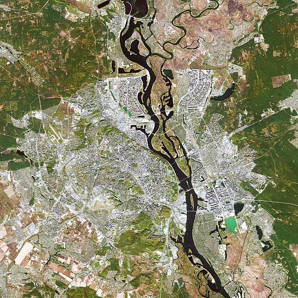
English: The Copernicus Sentinel-2 mission takes us over Kyiv – the capital and most populous city of Ukraine. Zoom in to see this image at its full 10 m resolution. Kyiv, also spelled Kiev, is visible just below the centre of the image, along the Dnieper River in north-central Ukraine. The city covers a total area of around 840 sq km and is home to approximately three million people. Originally just on the west bank, today the city of Kyiv spreads across both sides of the Dnieper River, which flows southwards through the city. The Dnieper is the fourth-longest river in Europe, after the Volga, Danube and Ural rivers. It rises on the southern slopes of the Valdai Hills of Russia and flows in a southerly direction through western Russia, Belarus and Ukraine to the Black Sea. Directly above the city of Kyiv is the Kyiv Reservoir – a large water reservoir which is 110 km in length and 12 km in width. The reservoir is mainly used for irrigation, hydroelectricity generation and industrial and public consumption. The neon green colours in the Kyiv Reservoir indicate a high quantity of algae. Algal blooms are dense layers of microscopic plants that occur on the surface of lakes, or other bodies of water, when there is an overabundance of nutrients on which algae depend. These high levels of nutrients are often caused by human pollution, such as wastewater or fertiliser runoff from agriculture. Owing to Ukraine’s climate and arable land, agriculture plays a large role in the country’s economy. Large, agricultural plots dominate this week’s image, with corn, wheat and barley being the country’s main crops. With over 40 million hectares of agricultural land covering 70% of the country, agriculture is Ukraine’s largest export industry. Copernicus Sentinel-2 is a two-satellite mission. Each satellite carries a high-resolution camera that images Earth’s surface in 13 spectral bands. The mission is mostly used to track changes in the way land is being used and to monitor the health of our vegetation. This image is also featured on the Earth from Space video programme. |
| Dato | la 11-a de decembro 2020 (alŝuta dato) |
| Fonto | Kyiv, Ukraine |
| Autoro | European Space Agency |
| Altra versioni |
|
| Activity | Observing the Earth |
| Mission | Sentinel-2 |
| Set | Earth observation image of the week |
| System | Copernicus |


.jpeg)
Licencizo

|
This image contains data from a satellite in the Copernicus Programme, such as Sentinel-1, Sentinel-2 or Sentinel-3. Attribution is required when using this image.
Atribuo: Contains modified Copernicus Sentinel data 2019
The use of Copernicus Sentinel Data is regulated under EU law (Commission Delegated Regulation (EU) No 1159/2013 and Regulation (EU) No 377/2014). Relevant excerpts:
Free access shall be given to GMES dedicated data [...] made available through GMES dissemination platforms [...].
Access to GMES dedicated data [...] shall be given for the purpose of the following use in so far as it is lawful:
GMES dedicated data [...] may be used worldwide without limitations in time.
GMES dedicated data and GMES service information are provided to users without any express or implied warranty, including as regards quality and suitability for any purpose. |
This media was created by the European Space Agency (ESA).
Where expressly so stated, images or videos are covered by the Creative Commons Attribution-ShareAlike 3.0 IGO (CC BY-SA 3.0 IGO) licence, ESA being an Intergovernmental Organisation (IGO), as defined by the CC BY-SA 3.0 IGO licence. The user is allowed under the terms and conditions of the CC BY-SA 3.0 IGO license to Reproduce, Distribute and Publicly Perform the ESA images and videos released under CC BY-SA 3.0 IGO licence and the Adaptations thereof, without further explicit permission being necessary, for as long as the user complies with the conditions and restrictions set forth in the CC BY-SA 3.0 IGO licence, these including that:
See the ESA Creative Commons copyright notice for complete information, and this article for additional details.
|
 | |
Ĉi tiu dosiero estas disponebla laŭ la permesilo Krea Komunaĵo Atribuite-Samkondiĉe 3.0 Interregistara Organizaĵo. Atribuo: ESA, CC BY-SA IGO 3.0
| ||
Historio dil arkivo
Kliktez sur la dato/horo por vidar arkivo quale ol aparis ye ta tempo.
| Dato/Horo | Miniaturo | Dimensioni | Uzero | Komento | |
|---|---|---|---|---|---|
| aktuala | 16:21, 11 dec. 2020 | | 3 258 × 3 258 (2,81 MB) | Don-vip | Cropped 24 % horizontally, 33 % vertically using CropTool with lossless mode. |
| 16:13, 11 dec. 2020 |  | 4 300 × 4 863 (5,25 MB) | Don-vip | File:Kyiv, Ukraine ESA22370890.jpeg cropped 61 % horizontally, 74 % vertically using CropTool with lossless mode. |
Ligilo al imajo
Ca pagini ligas al imajo:
Uzado en altra Wiki
La sequanta Wiki anke uzas ica arkivo:
- Uzado en af.wikipedia.org
- Uzado en el.wikipedia.org
- Uzado en en.wikipedia.org
- Uzado en fr.wikipedia.org
- Uzado en hi.wikipedia.org
- Uzado en id.wikipedia.org
- Uzado en ja.wikipedia.org
- Uzado en mt.wikipedia.org
- Uzado en pt.wikipedia.org
- Uzado en tr.wikipedia.org
- Uzado en zh.wikipedia.org
.jpeg)