Arkivo:Indian Rebellion of 1857.jpg

Grandeso de ica previdado: 713 x 599 pixels. Altra qualeso, en pixel-i: 286 x 240 pixels | 571 x 480 pixels | 914 x 768 pixels | 1 218 x 1 024 pixels | 1 959 x 1 647 pixels.
Arkivo originala (1 959 × 1 647 pixel-i, grandeso dil arkivo: 2,82 MB, MIME type: image/jpeg)
Titulo
| Priskribo |
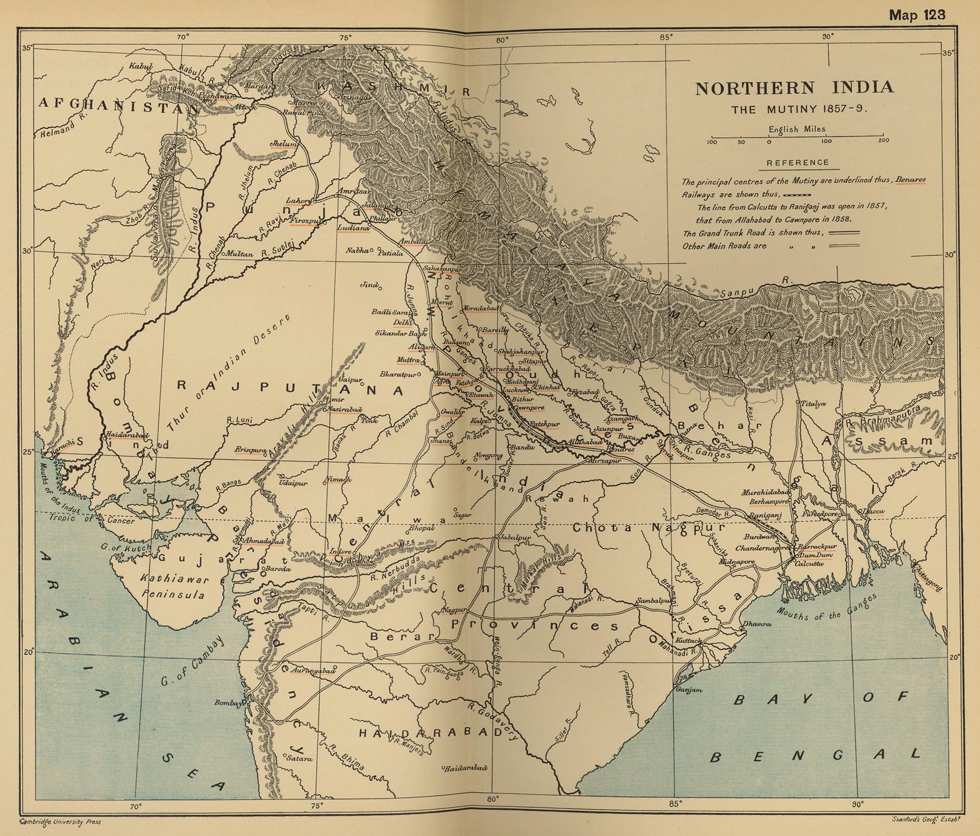
English: Map, "North India: The Mutiny 1857-9" from "The Cambridge Modern History Atlas". Cambridge University Press; London. 1912.
Editors were Sir Adolphus William Ward (†1924), G.W. Prothero (†1922), and Sir Stanley Mordaunt Leathes (†1938). Individual authors of works making up the atlas are not identified, nor are the likely to be, after reasonable research. Español: Mapa del norte de India |
|||||||||
| Dato | ||||||||||
| Fonto | Perry-Castañeda Library Map Collection Website. | |||||||||
| Kreinto |
Nekonata Cambridge University Press; Stanford's Geogl. Estabt.. |
|||||||||
| Geotemporal data | ||||||||||
| Bounding box |
|
|||||||||
| Georeferencing | ||||||||||
| Altra versioni |
|
|||||||||

Licencizo
|
Ita esas exakta riprodukto fotografala de artoverko bidimensiona qua esas en publika domeno. L'artoverko ipsa esas en publika domeno por la sequanta kauzi:
L'oficala pozeso di Wikimedia Foundation esas ke «exakta riprodukti de artoverki bidimensiona qua esas en publika domeno esas publika domeno».
Ta riprodukto fotografala esas do anke konsiderata esar en publika domeno en l'Unionita Stati di Amerika. Altraresortise, riuzo di ta kozo forsan esar restriktata; videz Riuzo di PD-Artofotografuri por lektar pluse. | ||||
Originala protokolo dum sendado dil arkivo
The original description page was on en.wikipedia (file log). All following user names refer to en.wikipedia.
- 2010-06-06 08:35 PawełMM 1959×1647× (1118753 bytes) vertical strip shadorws removed
- 2010-06-05 12:13 PawełMM 1959×1647× (1201791 bytes) central verticaly part flattened, cropped
- 2008-03-05 02:51 Fowler&fowler 1992×1700× (683065 bytes) Map, "North India: The Mutiny 1857-9" from "The Cambridge Modern History Atlas" edited by Sir Adolphus William Ward, G.W. Prothero, Sir Stanley Mordaunt Leathes, and E.A. Benians. Cambridge University Press; London. 1912. Downloaded by ~~~~ from the [h
- 2008-03-05 02:37 Fowler&fowler 1992×1700× (715404 bytes) Map, "North India: The Mutiny 1857-9" from "The Cambridge Modern History Atlas" edited by Sir Adolphus William Ward, G.W. Prothero, Sir Stanley Mordaunt Leathes, and E.A. Benians. Cambridge University Press; London. 1912. Downloaded by ~~~~ from the [h
Historio dil arkivo
Kliktez sur la dato/horo por vidar arkivo quale ol aparis ye ta tempo.
| Dato/Horo | Miniaturo | Dimensioni | Uzero | Komento | |
|---|---|---|---|---|---|
| aktuala | 15:35, 11 sep. 2012 | | 1 959 × 1 647 (2,82 MB) | Yann | color balance, contrast, color corrections |
| 07:45, 18 okt. 2010 |  | 1 959 × 1 647 (1,07 MB) | File Upload Bot (Magnus Manske) | {{BotMoveToCommons|en.wikipedia|year={{subst:CURRENTYEAR}}|month={{subst:CURRENTMONTHNAME}}|day={{subst:CURRENTDAY}}}} {{Information |Description={{en|Map, "North India: The Mutiny 1857-9" from "The Cambridge Modern History Atlas" edited by Sir Adolphus |
Ligilo al imajo
Ca pagini ligas al imajo:
Uzado en altra Wiki
La sequanta Wiki anke uzas ica arkivo:
- Uzado en ar.wikipedia.org
- Uzado en ast.wikipedia.org
- Uzado en azb.wikipedia.org
- Uzado en bg.wikipedia.org
- Uzado en bh.wikipedia.org
- Uzado en bn.wikipedia.org
- Uzado en br.wikipedia.org
- Uzado en cs.wikipedia.org
- Uzado en cy.wikipedia.org
- Uzado en en.wikipedia.org
- Uzado en es.wikipedia.org
- Uzado en fr.wikipedia.org
- Uzado en hi.wikipedia.org
- Uzado en id.wikipedia.org
- Uzado en ja.wikipedia.org
- Uzado en ka.wikipedia.org
- Uzado en lv.wikipedia.org
- Uzado en mai.wikipedia.org
- Uzado en mr.wikipedia.org
- Uzado en ms.wikipedia.org
- Uzado en ne.wikipedia.org
- Uzado en or.wikipedia.org
- Uzado en pa.wikipedia.org
- Uzado en pl.wikipedia.org
- Uzado en pnb.wikipedia.org
- Uzado en ru.wikipedia.org
- Uzado en sd.wikipedia.org
- Uzado en sr.wikipedia.org
- Uzado en sv.wikipedia.org
- Uzado en ta.wikipedia.org
- Uzado en te.wikipedia.org
- Uzado en th.wikipedia.org
- Uzado en tr.wikipedia.org
- Uzado en ur.wikipedia.org
- Uzado en vi.wikipedia.org
Videz altra uzadi por ica artiklo.