Arkivo:Enceladus PIA06191.jpg

Arkivo originala (3 750 × 2 876 pixel-i, grandeso dil arkivo: 1,05 MB, MIME type: image/jpeg)
Titulo
| Deskripto |
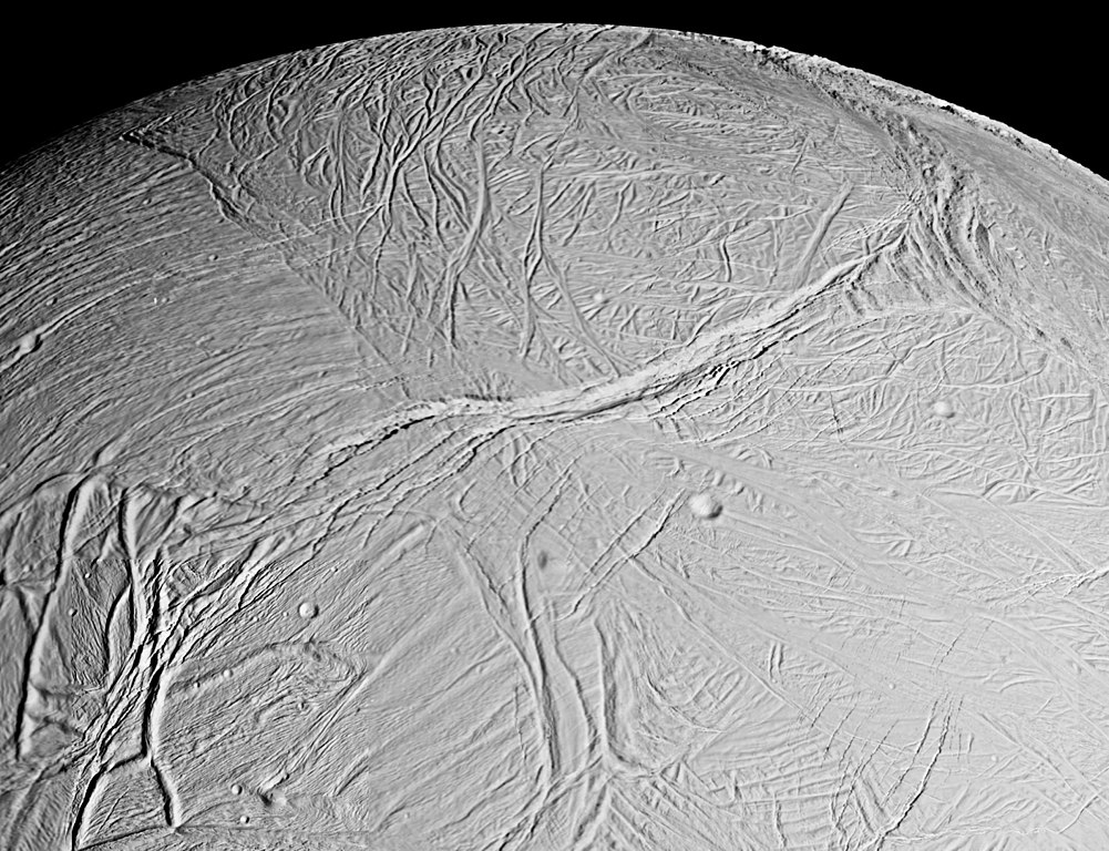
English: This spectacular view is a mosaic of four high resolution images taken by the Cassini spacecraft narrow angle camera on Feb. 16, 2005, during its close flyby of Saturn's moon Enceladus.
The view is about 300 kilometers (200 miles) across and shows the myriad of faults, fractures, folds, troughs and craters that make this Saturnian satellite especially intriguing to planetary scientists. More than 20 years ago, NASA's Voyager spacecraft gave hints of a surface cut by tectonic features, and subsequent images of other icy moons have revealed many different ways that stresses have acted on icy moon crusts. The new close-up images of Enceladus, which has a diameter of 505 kilometers (314 miles), show some familiar-looking features and others that are brand new. The work required to unravel their origins, their formation sequence, and the implications for the evolution of icy solar system bodies is just beginning. Voyager images of Enceladus, which were obtained at much poorer spatial resolution, showed terrains like those seen here. They were called "smooth plains" because they appeared to exhibit little topographic relief. However, Cassini has now viewed these terrains at almost 10 times better resolution. The new images reveal very complex systems of fractures, resurfaced terrain, and in some cases, topographic relief greater than several hundred meters. Many styles of fracturing are evident in this mosaic. Extending downward from the top center of the mosaic for hundreds of kilometers is a broad belt of complex, interwoven fractures. A huge rift 5 kilometers (3 miles)-wide dissects this belt and extends into several older-looking, distinct regions or "cells" of terrain that themselves exhibit distinct fracture patterns. Because Cassini flew rapidly past Enceladus, the right-side images were taken from a slightly different perspective than the left, and are delineated by the white box. The mosaic covers longitudes from about 254 west to 296 west and latitudes from 60 south to the equator. The images were taken in visible light on Feb. 17, 2005, at distances ranging from of 26,140 to 17,434 kilometers (16,243 to 10,833 miles) from Enceladus and at Sun-Enceladus-spacecraft, or phase, angles ranging from 27 to 29 degrees. Pixel scale in the left-side image is 150 meters (492 feet) per pixel; in the right-side (white box) image, scale is 105 meters (344 feet) per pixel. The image has been contrast-enhanced to aid visibility. |
| Dato | |
| Fonto | http://photojournal.jpl.nasa.gov/catalog/PIA06191 |
| Autoro | NASA/JPL/Space Science Institute |
This image or video was catalogued by Johnson Space Center of the United States National Aeronautics and Space Administration (NASA) under Photo ID: PIA06191. This tag does not indicate the copyright status of the attached work. A normal copyright tag is still required. See Commons:Licensing. Other languages:
|
Licencizo
| La ĉi-supra dosiero estas publika havaĵo, ĉar ĝi apartenas al NASA. La kopirajta regularo de NASA asertas, ke "ĉiuj dokumentoj de NASA estas publika havaĵo, se ne estas donata kontraŭa deklaro". | ||
 |
Atentu:
|
Historio dil arkivo
Kliktez sur la dato/horo por vidar arkivo quale ol aparis ye ta tempo.
| Dato/Horo | Miniaturo | Dimensioni | Uzero | Komento | |
|---|---|---|---|---|---|
| aktuala | 22:54, 1 apr. 2016 | | 3 750 × 2 876 (1,05 MB) | Banjo | better res |
| 15:50, 20 feb. 2005 |  | 2 340 × 1 580 (623 KB) | Bricktop | Enceladus image from NASA |
Ligilo al imajo
Ca pagini ligas al imajo:
Uzado en altra Wiki
La sequanta Wiki anke uzas ica arkivo:
- Uzado en ar.wikipedia.org
- Uzado en cs.wikipedia.org
- Uzado en da.wikipedia.org
- Uzado en de.wikipedia.org
- Uzado en en.wikipedia.org
- Uzado en en.wikinews.org
- Uzado en et.wikipedia.org
- Uzado en eu.wikipedia.org
- Uzado en gl.wikipedia.org
- Uzado en he.wikipedia.org
- Uzado en it.wikipedia.org
- Uzado en ja.wikipedia.org
- Uzado en lb.wikipedia.org
- Uzado en nl.wikipedia.org
- Uzado en pl.wikipedia.org
- Uzado en ro.wikipedia.org
- Uzado en ru.wikipedia.org
- Uzado en srn.wikipedia.org
- Uzado en sv.wikinews.org
- Uzado en uk.wikipedia.org
- Uzado en uz.wikipedia.org
- Uzado en www.wikidata.org
- Uzado en zh.wikipedia.org