Arkivo:Byzantine empire 1355.jpg

Grandeso de ica previdado: 758 x 600 pixels. Altra qualeso, en pixel-i: 304 x 240 pixels | 607 x 480 pixels | 971 x 768 pixels | 1 134 x 897 pixels.
Arkivo originala (1 134 × 897 pixel-i, grandeso dil arkivo: 380 KB, MIME type: image/jpeg)
Titulo
| Deskripto |
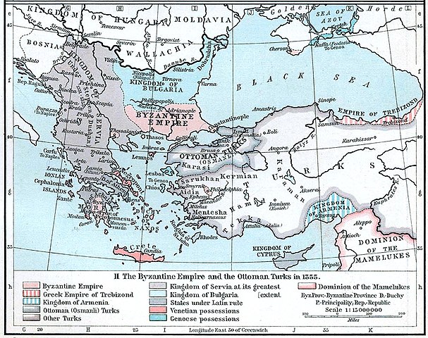
English: Map of the Byzantine, Ottoman and Serbian empires and their neighboring states, 1355. |
||||||||||||||||||||||
| Dato | |||||||||||||||||||||||
| Fonto | William R. Shepherd's Historical Atlas, p. 89, published by Henry Holt and Company, New York 1911 | ||||||||||||||||||||||
| Autoro |
|
||||||||||||||||||||||
| Altra versioni |
|
||||||||||||||||||||||

Licencizo
This work is in the public domain in the United States because it was published (or registered with the U.S. Copyright Office) before January 1, 1929.
Public domain works must be out of copyright in both the United States and in the source country of the work in order to be hosted on the Commons. If the work is not a U.S. work, the file must have an additional copyright tag indicating the copyright status in the source country.
Note: This tag should not be used for sound recordings. |
Historio dil arkivo
Kliktez sur la dato/horo por vidar arkivo quale ol aparis ye ta tempo.
| Dato/Horo | Miniaturo | Dimensioni | Uzero | Komento | |
|---|---|---|---|---|---|
| aktuala | 20:53, 6 dec. 2022 | | 1 134 × 897 (380 KB) | Gyalu22 | Artwork |
| 16:44, 29 mar. 2018 |  | 1 112 × 879 (908 KB) | Nihil scimus | Few improving (esthetic, contrast, genoese possessions 1355 since Westermann Grosser Atlas zur Weltgeschichte, 1985, ISBN 3-14-100919-8, p. 70, wallachian possessions 1355 under Nicholas Alexander [https://commons.wikimedia.org/wiki/File:Nicolae_Alexandru.jpg] since [https://en.wikipedia.org/wiki/Wallachia#/media/File:Wallachia_13-16c.svg]). | |
| 13:17, 8 nov. 2009 |  | 1 134 × 897 (380 KB) | Alex:D | whitened | |
| 16:00, 3 dec. 2005 |  | 1 134 × 897 (269 KB) | Migdejong | Map of the Byzantine Empire in the year 1355. Image comes from the University of Texas at Austin: http://geography.about.com/gi/dynamic/offsite.htm?site=http://www.lib.utexas.edu/maps/historical/history%5Feurope.html Map is released into the public |
Ligilo al imajo
Ca pagini ligas al imajo:
Uzado en altra Wiki
La sequanta Wiki anke uzas ica arkivo:
- Uzado en ar.wikipedia.org
- Uzado en azb.wikipedia.org
- Uzado en az.wikipedia.org
- Uzado en ba.wikipedia.org
- Uzado en bg.wikipedia.org
- Uzado en bs.wikipedia.org
- Uzado en ca.wikipedia.org
- Uzado en de.wikipedia.org
- Byzantinisches Reich
- Makedonien
- 1355
- Großserbien
- Marino Falier
- Andronikos IV.
- Beylik von Aydın
- Eroberung von Philadelphia
- Eroberung von Gallipoli
- Byzantinisch-genuesischer Krieg (1348–1349)
- Byzantinischer Bürgerkrieg (1352–1357)
- Byzantinischer Bürgerkrieg (1373–1381)
- Kreuzzug von Smyrna
- Benutzer:GerardM/Battles including the Ottoman Empire
- Uzado en el.wikipedia.org
- Uzado en en.wikipedia.org
Videz altra uzadi por ica artiklo.