Arkivo:Adygea districts.png

Grandeso de ica previdado: 785 x 600 pixels. Altra qualeso, en pixel-i: 314 x 240 pixels | 628 x 480 pixels | 1 013 x 774 pixels.
Arkivo originala (1 013 × 774 pixel-i, grandeso dil arkivo: 56 KB, MIME type: image/png)
Titulo
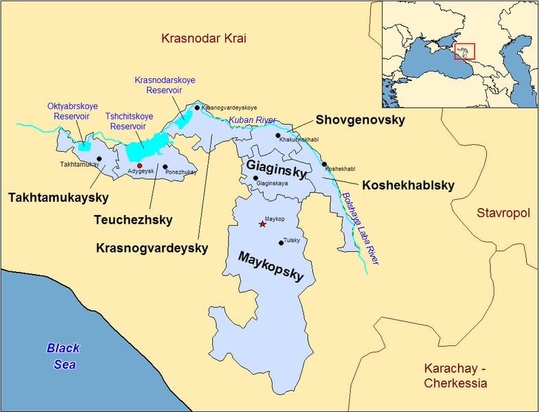
| Deskripto | Map of the districts of the Adygea republic of Russia. Created by Rarelibra 13:10, 30 March 2007 (UTC) for public domain use, using MapInfo Professional v8.5 and various mapping resources. |
| Dato | la 30-a de marto 2007 (origina alŝuta dato) |
| Fonto | No machine-readable source provided. Own work assumed (based on copyright claims). |
| Autoro | No machine-readable author provided. Rarelibra assumed (based on copyright claims). |
Previous summary and history (en.wikipedia)
Map of the districts of the Republic of Adygea (federal subject of Russia). Created by Rarelibra 20:52, 20 December 2006 (UTC) for public domain use, using MapInfo Professional v8.5 and various mapping resources. Special thanks to w:User:Ezhiki for both his patience and input to help complete this map for his wiki project.
- 16:06, April 3, 2007 . . Rarelibra (Talk | contribs | block) . . 1056×816 (58,397 bytes) (Updated version)
- 17:35, March 27, 2007 . . Rarelibra (Talk | contribs | block) . . 823×752 (50,852 bytes) (Updated map)
- 22:34, December 20, 2006 . . Rarelibra (Talk | contribs | block) . . 1281×878 (48,913 bytes) (Map of the districts of the Republic of Adygea (a federal subject of Russia). Created by ~~~~ for public domain use with attribution under GNU. Created using MapInfo Professional v8.5 and various mapping resources. Special thanks to User:Ezhiki for hi)
- 20:52, December 20, 2006 . . Rarelibra (Talk | contribs | block) . . 1281×878 (43,557 bytes) (Map of the districts of the Republic of Adygea (federal subject of Russia). Created by ~~~~ for public domain use, using MapInfo Professional v8.5 and various mapping resources. Special thanks to User:Ezhiki for both his patience and input to help com)
Licencizo
| Io, titolare dei diritti (copyright) su quest'opera, rilascio quest'opera nel pubblico dominio. Questo con effetto in tutto il Mondo. In alcuni paesi questo atto potrebbe non essere riconosciuto valido dalla locale normativa; in tal caso: Riconosco a chiunque e ciascuno il diritto di usare quest'opera per qualsiasi scopo, senza alcuna condizione, a meno che simili condizioni non siano validamente richieste dalla legge. |
Historio dil arkivo
Kliktez sur la dato/horo por vidar arkivo quale ol aparis ye ta tempo.
| Dato/Horo | Miniaturo | Dimensioni | Uzero | Komento | |
|---|---|---|---|---|---|
| aktuala | 22:53, 31 dec. 2023 | | 1 013 × 774 (56 KB) | User-duck | Cropped border using CropTool with lossless mode. |
| 13:18, 23 apr. 2007 |  | 1 056 × 816 (57 KB) | Rarelibra | Reverted to earlier revision | |
| 15:54, 21 apr. 2007 |  | 1 056 × 816 (46 KB) | David Kernow~commonswiki | ||
| 16:04, 3 apr. 2007 |  | 1 056 × 816 (57 KB) | Rarelibra | Updated version | |
| 13:10, 30 mar. 2007 |  | 823 × 752 (50 KB) | Rarelibra | Map of the districts of the Adygea republic of Russia. Created by ~~~~ for public domain use, using MapInfo Professional v8.5 and various mapping resources. |
Ligilo al imajo
Ca pagini ligas al imajo:
Uzado en altra Wiki
La sequanta Wiki anke uzas ica arkivo:
- Uzado en af.wikipedia.org
- Uzado en azb.wikipedia.org
- Uzado en ca.wikipedia.org
- Uzado en cy.wikipedia.org
- Uzado en de.wikipedia.org
- Uzado en el.wikipedia.org
- Uzado en en.wikipedia.org
- Uzado en fa.wikipedia.org
- Uzado en fi.wikipedia.org
- Uzado en frr.wikipedia.org
- Uzado en fr.wikipedia.org
- Uzado en incubator.wikimedia.org
- Uzado en it.wikipedia.org
- Uzado en krc.wikipedia.org
- Uzado en lv.wikipedia.org
- Uzado en mn.wikipedia.org
- Uzado en nl.wikipedia.org
- Uzado en pl.wikipedia.org
- Uzado en pl.wiktionary.org
- Uzado en pt.wikipedia.org
- Uzado en ru.wikivoyage.org