Arkivo:Malvern Hills - England.jpg

Grandeso de ica previdado: 800 x 464 pixels. Altra qualeso, en pixel-i: 320 x 185 pixels | 640 x 371 pixels | 1 024 x 594 pixels | 1 280 x 742 pixels | 2 560 x 1 484 pixels | 3 656 x 2 119 pixels.
Arkivo originala (3 656 × 2 119 pixel-i, grandeso dil arkivo: 2,41 MB, MIME type: image/jpeg)
Titulo
| Deskripto |
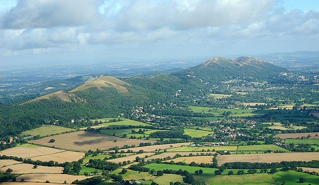
English: The Malvern Hills located in the English counties of Worcestershire and Herefordshire. The hills have been designated by the Countryside Agency as an Area of Outstanding Natural Beauty. The highest point is the Worcestershire Beacon at 425 metres (1,394 ft) above sea level. The range is a natural border between Worcestershire and Herefordshire. |
| Dato | |
| Fonto |
https://www.flickr.com/photos/davidchief/2765256316/
|
| Autoro | David Martyn Hunt |
| Pozicio de la fotilo | | Tiu cxi bildo kaj pliaj sur OpenStreetMap |
|---|
Licencizo
| This image, originally posted to Flickr, was reviewed on 4 March 2012 by the administrator or reviewer Materialscientist, who confirmed that it was available on Flickr under the stated license on that date. |
Ica arkivo havas la permiso Creative Commons Attribution 2.0 Generic.
- Vu povas:
- partigar – kopiar, distributar e transsendar la verko
- Mixar – adaptar l'arkivo
- Segun la sequanta kondicioni:
- Atribuo – Vu mustas referar l'artiklo o verko segun la formo definita dal autoro o dal proprietero dil autoroyuro, ed informar se modifikuri facesis. Vu mustas facar to per justa formo, ma ne insinuar ke l'autoro konfidis ol a vu, od aprobis vua uzo dil artiklo.
| Annotations | This image is annotated: View the annotations at Commons |

|
This image has been assessed under the valued image criteria and is considered the most valued image on Commons within the scope: Malvern Hills, England. You can see its nomination here. |
Historio dil arkivo
Kliktez sur la dato/horo por vidar arkivo quale ol aparis ye ta tempo.
| Dato/Horo | Miniaturo | Dimensioni | Uzero | Komento | |
|---|---|---|---|---|---|
| aktuala | 16:41, 24 apr. 2023 | | 3 656 × 2 119 (2,41 MB) | Artanisen | Highest quality (same source) |
| 12:53, 4 mar. 2012 |  | 1 003 × 577 (603 KB) | MrPanyGoff | cropped blown clouds | |
| 12:35, 4 mar. 2012 |  | 1 003 × 658 (635 KB) | MrPanyGoff |
Ligilo al imajo
Ca pagini ligas al imajo:
Uzado en altra Wiki
La sequanta Wiki anke uzas ica arkivo:
- Uzado en arz.wikipedia.org
- Uzado en ceb.wikipedia.org
- Uzado en de.wikipedia.org
- Uzado en de.wikivoyage.org
- Uzado en en.wikipedia.org
- Uzado en en.wikivoyage.org
- Uzado en fa.wikipedia.org
- Uzado en fr.wikipedia.org
- Uzado en he.wikipedia.org
- Uzado en is.wikipedia.org
- Uzado en it.wikivoyage.org
- Uzado en mg.wikipedia.org
- Uzado en pl.wikipedia.org
- Uzado en tr.wikipedia.org
- Uzado en www.wikidata.org
- Uzado en zh.wikipedia.org